This is a compilation of records for Donagh Parish which forms part of the Donegal Genealogy Resources Website
You may link to this page but not copy any of is content
If you have anything you'd like to add or would like to have yourself included in a Researchers section of these pages, then please Contact Me
Domhnach - Donagh
A parish, in the barony of ENNISHOWEN, county of DONEGAL, and province of ULSTER, containing, with the post-town of Carn, 5357 inhabitants. The ancient name given to Donagh by St. Patrick was Dom-nacli-Glinne-Tockuir, "the Sabbath-House of the Glen with Fountains :" there is but a slight variation in the former portion of this title, and the latter is still the name of the valley where the silver mines were formerly worked. From the book of Armagh and other authorities it appears that a religious establishment was founded here, in 412, by St. Patrick, of which he appointed McCarthen, brother of the saint of Clogher, bishop, or abbot: of the several crosses which marked the limits of its sanctuary one only remains; the saint's penitential bed, and other relics, having been preserved here, this place was much resorted to by pilgrims on St. Patrick's day. The parish is situated on the shore of the bay of Straghbregagh, or Strabreagy, and is intersected by the roads leading from Londonderry to Malin and Malin Head, from Moville to Buncrana, and from Londonderry to Clonmany. It comprises, according to the Ordnance survey, 25,259 1/4 statute acres, the greater part of which are mountain and bog, incapable of being cultivated; small detached portions of land, under tillage, at the foot of the numerous mountains, extending from Glen Tocher to Strabreagy, yield oats, flax, potatoes, and some wheat and barley. Slieve Snaght, or the mountain of Snow, is the highest; according to the above survey, it rises 2019 feet above the level of the sea. From its northern side issues a small river, which runs through the town of Cam, and near the foot of this mountain is a pretty cascade, called Earmaceire. The mountains are mostly of schist, and slate and excellent flagstones are also found in them, besides extensive knolls and ranges of blue limestone. The limestone in Glen Tocher is remarkably good; the silver mines there were worked by an English company about 1790, but owing to the intimidation of the miners they were abandoned, and the attempt to work them has not been resumed. Two small tuck-mills employ about 12 people, but the greater part of the inhabitants are engaged in agricultural pursuits and in fishing. The parish contains numerous good houses, the principal of which are noticed under the head of Cam, which see.
The living is a rectory, in the diocese of Derry, and in the patronage of the Marquess of Donegal: the tithes amount to £365. The glebe-house is situated in the midst of a bog, one mile from the church, on the shore of the bay : sixty acres of good land were reserved, for the glebe of this parish, in the grant of the barony of Innishowen, by James I., to Sir Arthur Chichester; the glebe now comprises 162 Cunningham acres, about 50 of which are under cultivation, and more are being reclaimed. The church is a small neat edifice, erected in 1769; the walls were newly raised, newly roofed, and otherwise improved in 1812. The R. C. parish is coextensive with that of the Established Church, and is called Carndonagh; there is a large and handsome chapel in the town of Cam, built in 1826, at a cost of £1200. At Cam is also a large meeting-house for Presbyterians in connection with the Synod of Ulster. Besides the school at Carn, there are others under the National Board at Glen Tocher, Glengennan, and Glasalts; also one private and two Sunday schools, one of which is in connection with the Presbyterian meetinghouse. A stone cross, six feet high, hewn out of a solid block, and ornamented with numerous scrolls and shamrocks, stands near the church; close adjoining which are the square shafts of two others, having on each side the figure of a human head. There are several forts in the parish.
(Extract from A Topographical Dictionary Of Ireland by Samuel Lewis, 1837)
Last updated 10 Aug 2019
Births, Marriages and Deaths
- Births
- Marriages
- Deaths
Books
- A Cottage in Donegal, Mary Doherty's Story - Eva Doherty Gremmert
- The Poet Scout - Capt Jack Crawford 1879
Census
- 1740 Census
- 1841/51 Census
- Census Search Forms/Old Age Pension Applications
- 1901 Census
Note1: Census in green are online (select them to go to the transcription)
- Altashane Or Cabadooey
- Ballyloskey
- Carndonagh
- Carndonagh Town
- Bridge Street
- Chapel Street
- Malin Street
- Market Square
- Pound Street
- Churchland Quarters
- Glasalt Or Treanfasy
- Glebe
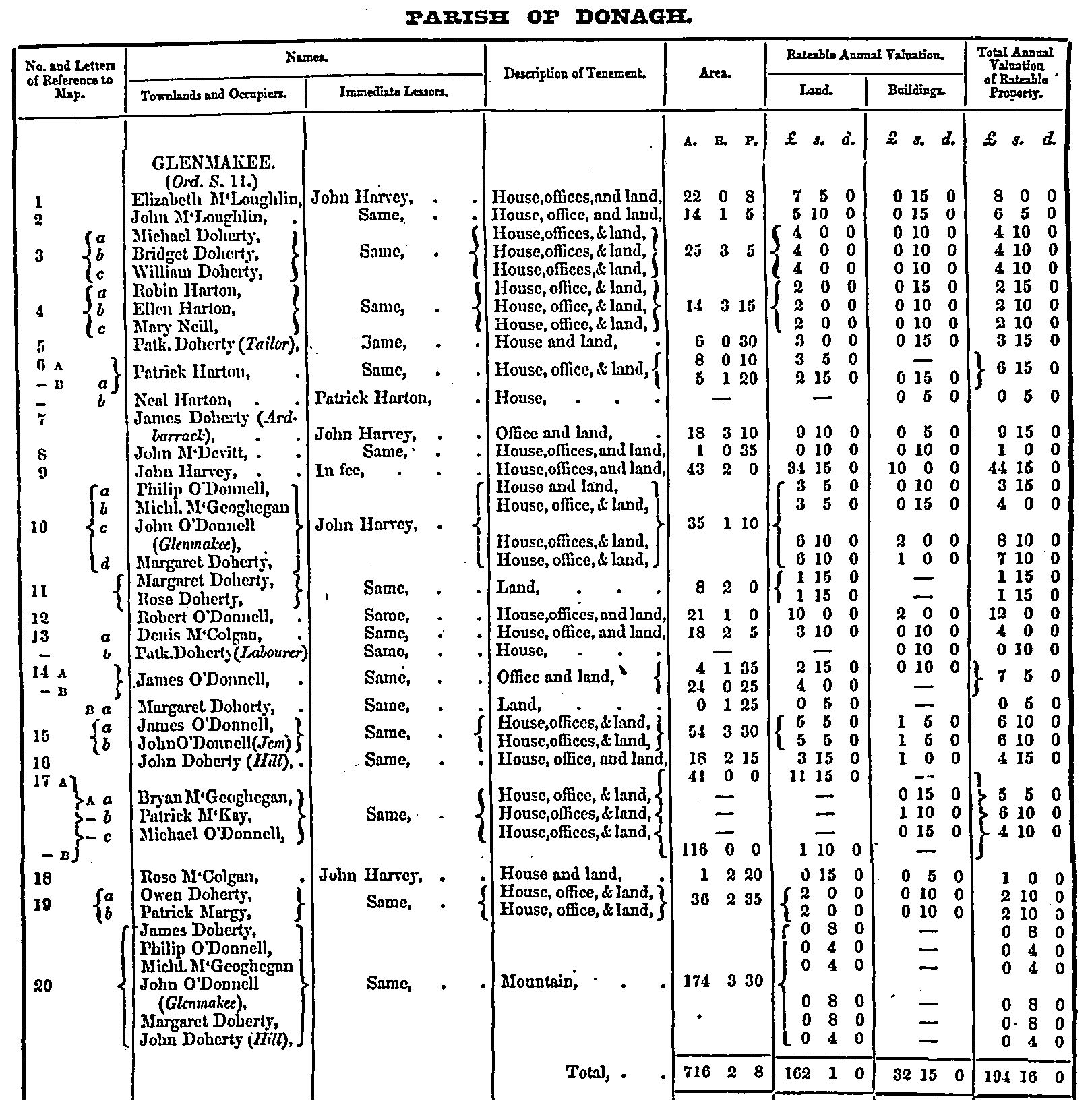
- Glenmakee
- Complete 1901 census online at NAI Census Website
- 1911 Census
Churches
- Church of Ireland
- Presbyterian
- Roman Catholic
Families
Famine
Headstone Inscriptions (soon)
- Church of Ireland
- Donagh Parish Church
- Presbyterian Church
- Carndonagh Presbyterian Church
- Roman Catholic
- Sacred Heart
Land
- 1665 Hearth Money Roll
- 1796 Spinning Wheel Premium Entitlements List (Flax List)
- 1800 Donegal Supporters of the Act of Union (Donagh)
- 1819/1827 List of Rentals (Carricktemple or the Churchland Quarter, BallyBrienougher, Mough, Moyshandoney and Carrick) new
- 1827-33 Civil Bill Ejectments
- 1828 Tithe Applotment Book
- 1829-31 Applications to Register Freeholds in the Barony of Ennishowen
- 1857 Griffith's Valuation Index
- 1857 Griffith's Valuation online
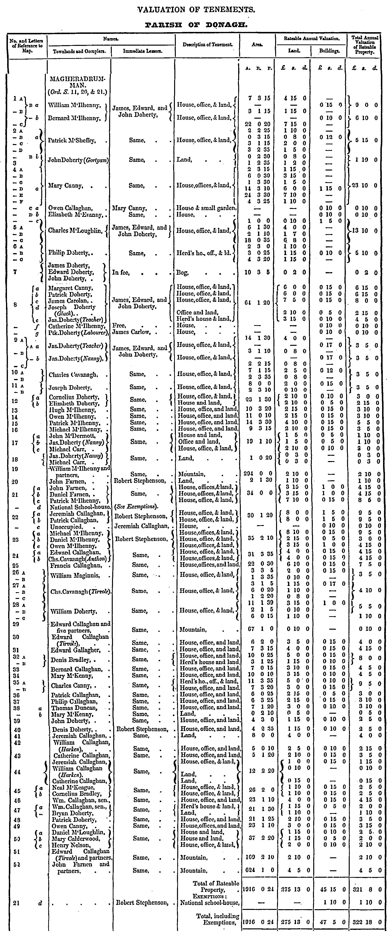
- 1857 Griffith's Valuation Detailed :

Maps
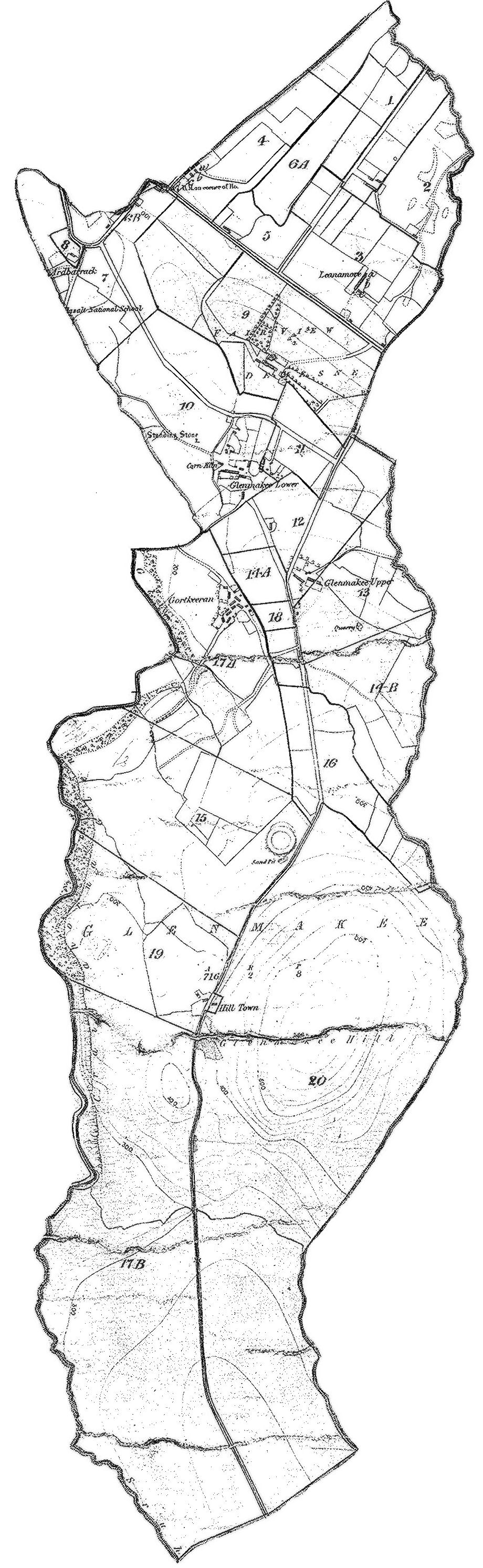
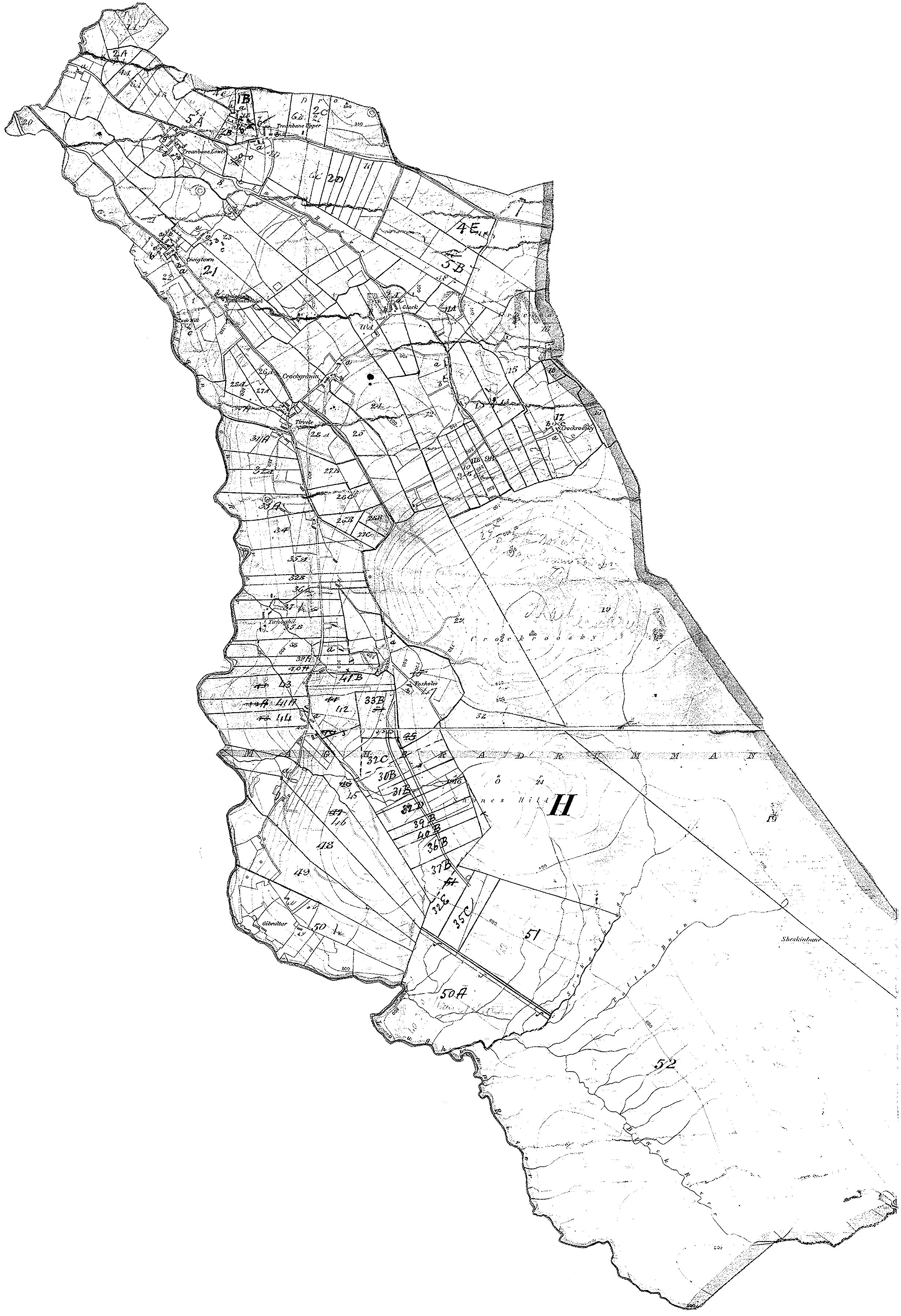
- 1835 Ordnance Survey Maps
- Parish
- Parish Map & Data (Bob Hilchey)
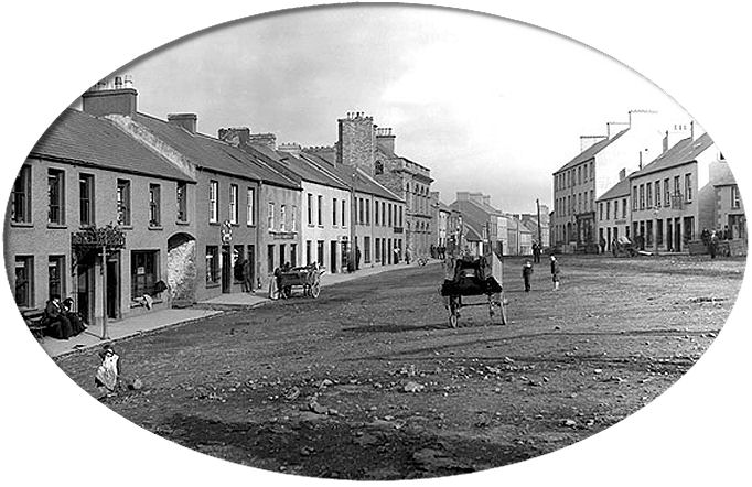
Photographs
People
Researchers
Resources
- LDS Films
Townlands
Townland Also Known As Area Altashane Cabadooey 1,591 Ballylosky - Baile Bhloscaidh 705 Cabadooey Altashane 1,591 Carndoagh 607 Carndonagh Town Carrickafodan 777 Carrowblagh 2,414 Carrowmore Glentogher 5,784 Carrowreagh 1,803 Cashel 1,449 Churchland Quarters (Carrowtemple, Moneyshandoney, & Carrick) 5,187 Glasalt Treanfasy 1,448 Glebe 267 Glenmakee 716 Glentogher Carrowmore 5,784 Gort Glebe 5 Magheradrumman 1,916 Treanfasy Glasalt 1,448 Tullanree 581
© 1998 Donegal Genealogy Resources